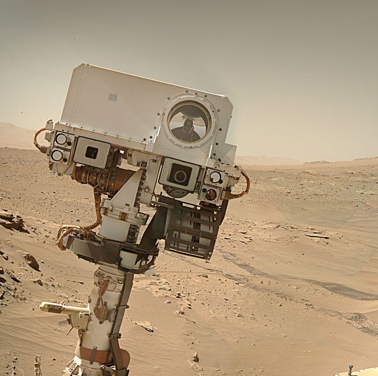
Thanks for posting this, Paul; I had meant to go through this year’s abstracts more closely, so this saves me some time!
The image, aside from being spectacular and essential for visualizing this mission’s progress, is one of those key diagrams that needs to be on a regularly-maintained “reference page” somewhere.
I’m just as guilty, I also missed it when I went through the abstracts. It was posted by one of the amateur mappers over on UMSF Discord :) Back in the day when I used to post to FB I maintained a reference FB-Note, but FB decided they did not need notes anymore and it was lost. Not long back I quit FB when they started playing silly games. I’m currently in the middle of removing all my connections to Google, but if you’re still using Google I can point you to a maintained traverse map of MSL that’s is integrated into Google Earth. The guy who does it posts updates every few drives and he includes all the notional paths. He even has links to higher res map tiles that can be integrated into Google Earth Pro (the free version). Let me know if you’re interested
Here you go… It’s a link to his Google Drive. In the folder you’ll find a PDF that requires a minor update as it still points to UMSF (now defunked) but Fernando is waiting for UMSF to be resurrected that process is in work, and once done he’ll update the PDF user manual. The KMZ file in the folder is the one you open to update the map on Google Earth. The current version reflects the rover’s current location. The folder also contains the high resolution map tiles to install inside Google Earth.
You are a gentleman and a scholar, Paul, thank you. Much credit to Fernando Nogal, as well. My PC is having a mid-life crisis, so I haven’t been able to look at that orbital map file yet, but this is all inspiring to see. I am very much looking forward to UMSF being reconstituted.
Would you mind if I sent you a DM? I wanted to ask your opinion about writing “guides” of a somewhat similar kind.
A new version of the KMZ file has just been posted by Fernando (you’ll find it on his drive), it adds place names and extends the traverse to the new location after the drive on sol 4507. I used to find it better to delete the old traverse folder in GE before installing the new one :)
Thanks for posting this, Paul; I had meant to go through this year’s abstracts more closely, so this saves me some time!
The image, aside from being spectacular and essential for visualizing this mission’s progress, is one of those key diagrams that needs to be on a regularly-maintained “reference page” somewhere.
I’m just as guilty, I also missed it when I went through the abstracts. It was posted by one of the amateur mappers over on UMSF Discord :) Back in the day when I used to post to FB I maintained a reference FB-Note, but FB decided they did not need notes anymore and it was lost. Not long back I quit FB when they started playing silly games. I’m currently in the middle of removing all my connections to Google, but if you’re still using Google I can point you to a maintained traverse map of MSL that’s is integrated into Google Earth. The guy who does it posts updates every few drives and he includes all the notional paths. He even has links to higher res map tiles that can be integrated into Google Earth Pro (the free version). Let me know if you’re interested
I am definitely interested, Paul! I love me a drowning in data! Hit me!
Sorted - I’ll gather the download links etc and send them in the next day or so :)
If you don’t already have it installed, get yourself the pro version of Google Earth installed (it’s free)
Here you go… It’s a link to his Google Drive. In the folder you’ll find a PDF that requires a minor update as it still points to UMSF (now defunked) but Fernando is waiting for UMSF to be resurrected that process is in work, and once done he’ll update the PDF user manual. The KMZ file in the folder is the one you open to update the map on Google Earth. The current version reflects the rover’s current location. The folder also contains the high resolution map tiles to install inside Google Earth.
https://drive.google.com/drive/folders/1OJHhlAIftz_fh-CcJsG33JAOalrEHBbQ?usp=drive_link
You are a gentleman and a scholar, Paul, thank you. Much credit to Fernando Nogal, as well. My PC is having a mid-life crisis, so I haven’t been able to look at that orbital map file yet, but this is all inspiring to see. I am very much looking forward to UMSF being reconstituted.
Would you mind if I sent you a DM? I wanted to ask your opinion about writing “guides” of a somewhat similar kind.
I had no idea you could send DM’s here :) But sure go ahead, I’ll help in anyway you can.
A new version of the KMZ file has just been posted by Fernando (you’ll find it on his drive), it adds place names and extends the traverse to the new location after the drive on sol 4507. I used to find it better to delete the old traverse folder in GE before installing the new one :)