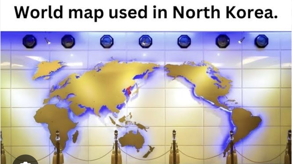
I’m no map understander, but I think the projection choice might have not been the best cause it seems to skew edges, while the part that it maintains has a lot of empty space (or maybe I’m just used to other maps). Though this is just a random map on a wall so 🤷
The solution is to create a new continent in the Pacific.
You are used to other maps. Yours are skewed the same way, at least when referencing the versions with curved edges (Robinson), but you just see the same anglo-centric projections, being centered on the prime meridian from the northern hemisphere. The USA is a little bigger than shown on the “normal” map. Greenland is quite smaller than represented. South America/Africa/Australia are significantly undersized. And there’s no hope for understanding Antarctica in either version.
Yes, but the maps we’re more used to split in the middle of the Pacific, far from all land, more or less at Point Nemo. That minimizes the visual distortion since the land is further from the edges of the map.
Splitting through the Atlantic makes it trickier, because the ocean is significantly narrower, meaning that the land masses are all closer to the edges.
Positioning the map with North at the top is truly arbitrary, but splitting the map in the Pacific actually makes a lot of sense from a usability perspective.
Less land? Sure, but not away from all land. Less people, debatable. The Atlantic split makes it hard to notice Alaska and Russia are miles apart. It also makes it seems like hundreds of pacific islands are at the edge of the world, isolated. It presents the Americas and Asia as, literally, a world apart. No matter where you draw your centerline, the edges have greatly distorted distances. It’s not just continental mass that’s important, but aquatic distances as well.
I don’t think it’s particularly debatable that more people live in Europe and Africa and South America (the most notably distorted landmasses in the Pacific-centered map) than in Alaska, Eastern Russia, and the few Pacific isles that aren’t tucked right in next to Continental Asia and Australia. The most populous nation negatively affected by a Pacific split is probably New Zealand, and that only represents about five million people. The most populous nation negatively affected by an Atlantic split is probably Brazil, with over forty times as many people.


That is common in east Asia in general, and I don’t see why not 🤷
Exactly, no one here played Street Fighter 2 on SNES?!
I’m no map understander, but I think the projection choice might have not been the best cause it seems to skew edges, while the part that it maintains has a lot of empty space (or maybe I’m just used to other maps). Though this is just a random map on a wall so 🤷
The solution is to create a new continent in the Pacific.
I’m trying but they keep cleaning up my plastic
You are used to other maps. Yours are skewed the same way, at least when referencing the versions with curved edges (Robinson), but you just see the same anglo-centric projections, being centered on the prime meridian from the northern hemisphere. The USA is a little bigger than shown on the “normal” map. Greenland is quite smaller than represented. South America/Africa/Australia are significantly undersized. And there’s no hope for understanding Antarctica in either version.
Yes, but the maps we’re more used to split in the middle of the Pacific, far from all land, more or less at Point Nemo. That minimizes the visual distortion since the land is further from the edges of the map.
Splitting through the Atlantic makes it trickier, because the ocean is significantly narrower, meaning that the land masses are all closer to the edges.
Positioning the map with North at the top is truly arbitrary, but splitting the map in the Pacific actually makes a lot of sense from a usability perspective.
Less land? Sure, but not away from all land. Less people, debatable. The Atlantic split makes it hard to notice Alaska and Russia are miles apart. It also makes it seems like hundreds of pacific islands are at the edge of the world, isolated. It presents the Americas and Asia as, literally, a world apart. No matter where you draw your centerline, the edges have greatly distorted distances. It’s not just continental mass that’s important, but aquatic distances as well.
I don’t think it’s particularly debatable that more people live in Europe and Africa and South America (the most notably distorted landmasses in the Pacific-centered map) than in Alaska, Eastern Russia, and the few Pacific isles that aren’t tucked right in next to Continental Asia and Australia. The most populous nation negatively affected by a Pacific split is probably New Zealand, and that only represents about five million people. The most populous nation negatively affected by an Atlantic split is probably Brazil, with over forty times as many people.
And it has New Zealand on it!