

Mt. Fluchthorn’s tallest peak, on the Swiss-Austrian border, collapsed in June.
Experts say peaks in the European Alps and Southern Alps of New Zealand are at risk of collapse, too.
The damage and dangers from mountain collapse disproportionately impact indigenous communities.
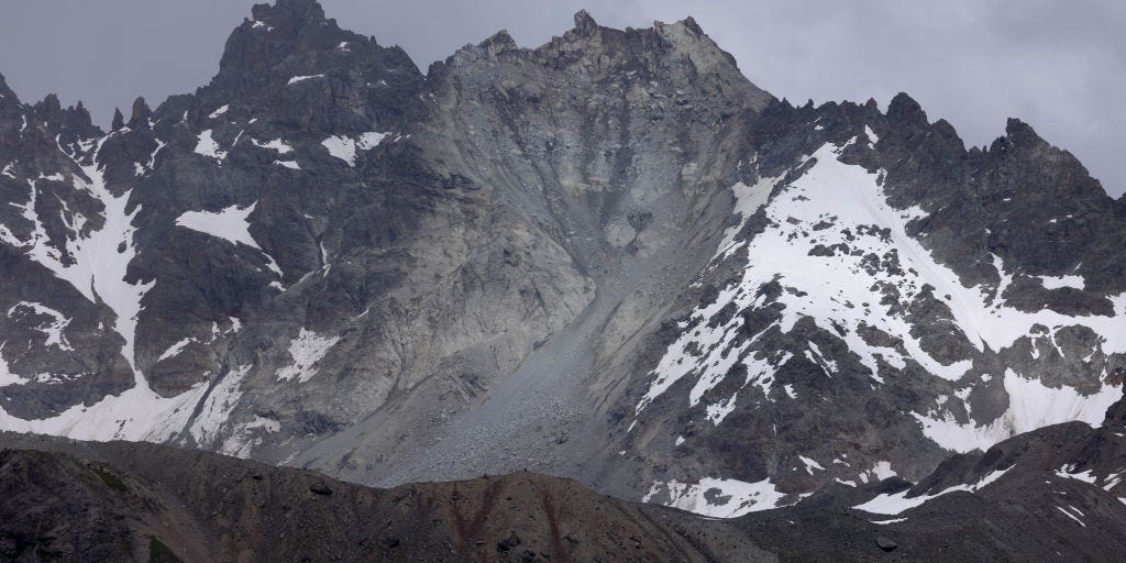
On June 11, the main peak of Mt. Fluchthorn, on the border of Austria and Switzerland, collapsed without warning.
Roughly 3.5 million cubic feet of earth tumbled down, filling the valley below with 40 Olympic swimming pools’ worth of rocks, mud, and dirt, LiveScience reported. While no people got hurt, a religious cross marking the summit was destroyed.
Fluchthorn had three peaks, and the main, southern one used to be the tallest. With the south peak collapsed, the middle peak is the new summit at 11,145 feet — the second-highest summit in the Silvretta Alps.
Overall, Mt. Fluchthorn is 60 feet shorter than it was earlier this year, per LiveScience.
Why did the peak collapse? Well, like many mountains in the far north, Fluchthorn had a lot of permafrost — a permanent layer of ice and dirt under the mountain’s surface.
“Permafrost is important because frozen water within the ground holds the ground surface together and prevents it from moving. But when that ice melts, the liquid water can flow away. The ground surface becomes less stable and can move, often very quickly,” said Jasper Knight, a geoscientist at the University of Witwatersrand in South Africa.
When a big chunk of mountain moves quickly, like with the mudslide at Fluchthorn, that’s called a mass movement.
“Global warming is causing the permafrost to melt, which is the trigger for these mass movement events to take place,” Knight said.
This is the best summary I could come up with:
Roughly 3.5 million cubic feet of earth tumbled down, filling the valley below with 40 Olympic swimming pools’ worth of rocks, mud, and dirt, LiveScience reported.
Across the world, mountains with permafrost melt have shown larger and more frequent landslides, the Intergovernmental Panel on Climate Change reported.
Mass movements can also increase the risk of blocked roads, damaged farmland, and mercury contamination in local bodies of water.
Argumedo and Stenner said Andean indigenous peoples have an in-depth system of traditional knowledge to predict and cope with extreme weather conditions on the mountainside.
One strategy they use are agricultural terraces — step-like tiers of farmland set along the mountain’s slope — that “prevent soil erosion and landslides,” Argumedo said.
He added that for the terrace strategy to work, the top of the mountain needs natural pasture and native tree species to act as sponges for extra water.
I’m a bot and I’m open source!